 |
| Summerland |
“The hills are alive with the sound of music...." The
lyrics of The Sound of Music will echo as you hike along Summerland
trail. Summerland is, perhaps, one of the most beautiful hikes in Mt.
Rainier National Park. It is part of
Wonderland Trail (93 mile loop trail which goes around Mt. Rainier) and also the highest
segment of the loop.
Summerland trail travels along Fryingpan Creek
and gradually ascends through the forest for the first 3 miles with grand
vistas of waterfalls and mountain peaks. Be entertained with a number of creek-crossings and log bridges one after another, and the hike is pleasant and exciting, but never monotonous. The trail climbs steep for the last 1 mile in
tight switchbacks before reaching the splendor of Summerland’s spectacular mountain vistas and beautiful wild flower meadows. Enjoy the reward after the final push. It is such a heavenly place....“the hills are alive
with the sound of music”.
The following 2 miles from Summerland lead you up to
Panhandle Gap…the land of rocks and snow/ice. The trail climbs the eastern wall
of Summerland basin by Fryingpan Glacier, and the last ascent of the trail is to
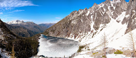
traverse the steep ridge of Panhandle Gap (6,800’) and scramble to the rocky top. The views are spectacular....behind the
trail is Summerland and Mount Rainier with glacier views, and on the opposite side the valley of
Ohanapecosh pans out toward Indian Bar which is a halfway point to Box Canyon. Take
a good look at the view south of Panhandle Gap as you ascend. The towering peak seen in the distance is Mt. Adams (12.280’).
Summerland is a great hike where you can experience in just one day the essence of what Wonderland
Trail offers. It’s not
only a wonderful wilderness hike, but also an unforgettable journey for its beauty and
splendor.
Roundtrip - 12 miles
Elevation Gain - 2,950’
Highest Point - 6,800’
How to get there: From Enumclaw, drive east 43
miles on State Route 410 to the Mount Rainier National Park White River
Entrance. Drive about 4 miles on Sunrise
Road to the trailhead parking near the bridge over Fryingpan Creek.
 |
| Panhandle Gap |


