Wednesday, December 4, 2013

Ptarmigan Ridge - Mt. Baker, WA


Ptarmigan Ridge/Mt. Baker, WA - 9/2013

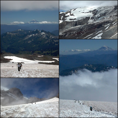
What a perfect day it was for the last summer day in PNW! Mt. Baker's Ptarmigan trail was full of hikers marching in and out to make it memorable at the end of the season.

Amazing hike, I must say....Ptarmigan Ridge. I'd list this trail among my top 5 most beautiful and spectacular hikes in N. Cascades. You must do this hike to believe me. I couldn't resist feeling awestruck and dropping my jaw all along. Don't forget to look back as you hike because Mt. Shaksun and Mt. Baker keep following you in front and in back, also with N. Cascades range on your side. Part of Ptarmigan Ridge is normally covered with perpetual snow and ice even in summer, but the unusually warm weather this summer melted snow/ice and exposed Ptarmigan's moon-like landscape creating an effortless access to view Coleman Glacier (north climbing route to summit Mt. Baker). I saw 7 mountain goats en route, which was a pleasant surprise and special treat with such an amazing hike.  Two thumbs UP!  By the way, to add to the memorable hike, save your time to stop by at Picture Lake and capture a mirror reflection of Mt. Shuksan before sunset.  It is picturesque, indeed.


How to get there:
From Bellingham follow the Mount Baker Highway (State Route 542) east for 34 miles to the Glacier Public Service Center. Drive another 25 miles to the road end at the mega parking lot for Artist Point (elev. 5140 ft). Privy available.

Trailhead....Artist Point
Distance....10 miles RT
Elevation gain....1,900 ft


Granite Mountain, WA

Granite Mountain, WA - 10/2013

What a gorgeous day it was! The weather was almost like summer and perfect hiking in T-shirt and shorts while Seattle remained fogged in and cold. When I snowshoed up to the Granite's lookout via the avalanche chute two years ago, I could only experience the south face of the mountain. This time hiking along the trail to the lookout gave me a chance to see the back side of the mountain, which was very enjoyable. The trail condition is moderate over all with some muddy spots and running water, but no biggie. About a foot deep snow begins after passing the meadow (3.5 miles from trailhead), and the snow gets slushy as you climb the last stretch to the lookout. Trekking poles are helpful to hike up the steep switchbacks covered with slushy snow. This is a strenuous hike as the trail gets steeper....3,800 feet elevation gain in 4 miles. It's a butt kicker, and you feel your thighs burning as you push to ascend. But, the reward you see at the summit is worth the effort. The 360 vistas from the lookout are spectacular, indeed....how many peaks can you name on sight? Fall colors are still beautiful in and around the open meadow, but fading fast. Ranger is on duty in the lookout. He was giving fresh baked cookies to hikers....delicious! He said he'd be there on duty until Wednesday. You may hike up to the lookout by then? Granite Mountain is a great hike now for fall colors with breathtaking views and no doubt butt kicking workout....and perhaps, for ranger's fresh baked homemade cookies! 

How to get there:
From Seattle drive east on I-90 to exit 47 (Asahel Curtis/Denny Creek). Turn north over the freeway, turn left at the T, and drive to the nearby Pratt Lake-Granite Mountain parking area.

Roundtrip 8.0 miles
Elevation Gain 3800 ft
Highest Point 5629 ft


Kendall Katwalk, WA


Kendall Katwalk, WA - 10/2013


If you want to hike Kendall Katwalk this year, you may still have a chance before the next summer. The Katwalk is snow free as of Oct. 26, 2013, thanks to all the sunny weather in the highlands above the fog for the last few weeks. But, the window of opportunity depends on how long the mild fall weather will sustain. Kendall Katwalk was one of my bucket list hikes for the last few years, so I'm glad I could do this hike this time before the hiking season phases out. This is a spectacular hike with breathtaking vistas of towering mountains and traversing a sheer cliff - the Katwalk. The trail is well maintained and gradual ascent although it's a bit long hike - 11 miles RT and 2,700 feet gain. I saw quite a few trekkers running on the trail, about a dozen or so. The trail must be a great workout spot for runners. About 0.5 miles before you reach the Katwalk, there are a few stretches of icy snow you have to cross (trekking poles are recommended)....enjoy a little thrill. Muddy spots, creek crossing, water falls and mossy forest with lots of mushrooms are your company until the trail breaks open into meadows - Kendall Gardens. Be inspired with the spectacular mountain views all along from there to the Katwalk...Mt. Rainier, Mt. Stuart, Red Mountain and other N. Cascades peaks you are familiar with. After crossing the Katwalk, you can keep trekking along PCT deep farther north into wilderness if you want, or turn around to the way you came from. The fall weather was perfect today, and the hike was SUPER! Fall foliage is about to end its display now.

How to get there:
From Seattle drive I-90 to exit 52 (signed for Snoqualmie Pass west). At the bottom of the exit ramp, turn left (north) and cross under the freeway. In about 100 yards, turn right onto a dirt road leading into the PCT trailhead. Northwest Forest Pass required to park at trailhead.

Roundtrip 11.0 miles
Elevation Gain 2700 ft
Highest Point 5400 ft


Lake Ingalls, WA


Lake Ingalls, WA - 10/2013

This is one amazing hike and pristine wilderness you can experience if you want everything in one hike, particularly now to view fantastic golden fall colors of larches. This week may be the last chance to catch that. You can read other trip reports on Lake Ingalls for details which I found useful for my trip. Hence, my trip report is to be short and simple, and just to say TWO THUMBS UP! The hike also offers a variety of terrains to hike along (forest, water falls, switchbacks, traversing saddles, scrambling) and various vegetation/rock formations with grand vistas of mountain peaks all along until you reach Lake Ingalls. Be ready to drop your jaw as you trek up switchbacks and magnificent Mt. Stuart greets you at the pass....Wow! The snow is already 1 -2 feet deep over the pass, but you can follow well packed snow trail to reach the tarn. Route finding and ascending to the lake may be a bit tricky part of the way due to the snow. The snow was slushy when I started the switchback section around 1pm. Trekking poles are useful, and calculate the starting/returning time of your hike for the snow's slippery condition. I started a bit late around noon, reached the lake by 2:30, and trek back to my car a little after 5pm. If I had started earlier, I would have had more leisure time at the lake. It took me 3 hrs to get to the trailhead from Seattle. The last 10 miles of the unpaved road to TH are full of potholes (some are huge and deep!), so just go slow and take it easy. I highly recommend this hike. Feed your soul with all the spectaculars!

  
How to get there:
From Seattle drive east on I-90 to East Cle Elum, exit 85. Cross over the freeway overpass and turn right (northbound) on State Route 970. Cross the Teanaway River bridge, and in another mile turn left onto Teanaway Road. Drive north on Teanaway Road, veering right as it becomes first the North Fork Teanaway Road and then unpaved Forest Road 9737 at 29 Pines Campground. Continue to the road's end.

Roundtrip 9.0 miles
Elevation Gain 2500 ft
Highest Point 6500 ft


Saturday, August 24, 2013

Camp Muir, WA - Third Ascent

Last Sunday I aimed at my third ascent to Camp Muir (10,100') - base camp for scaling Mt. Rainier (14,400'). It started out with a gorgeous blue sky, but when we reached above 7,000' near Pebble Creek, the notorious mountain cloud started to roll in....Mt. Rainier forms its own clouds at any time regardless of weather...."whiteout". Also, wind picked up and temperature dropped quickly.  But, we judged it would be safe to continue to ascend as other hikers kept going up and down as well....the visibility was about 100' - 200', depending on clouds density.  Wildflowers were abundant all over displaying beautiful colors along the trail....the very reason many people visit Mt. Rainier during this time of the year and autumn. In fact, I've seen a tourist strolling with her high heels on along the paved trail, no kidding! The views from Camp Muir was awesome and even magically austere with clouds rolling in before our eyes. It was a great hike with a little adventure as we breathed deep the thin air into above 10,000'.


Round trip  10 miles
Elevation Gain  4,600 ft
Highest Point  10,100 ft


"Mount Rainier contains the most luxuriant and the most extravagantly beautiful of all the alpine gardens I ever beheld in all my mountain-top wanderings."  - John Muir -


*Click to view large.


(Properties of Special Collections, University of Washington Libraries)


Sauk Mountain - WA

Sauk Mountain - Recently I read about this hike and was intrigued.  Drive up to trailhead at 4,000 ft on the rather rough forest road - pot holes and wash board.....but, no worries, you don't need a SUV, carefully driving, though.  The trail is short - 4.5 miles RT, and only 1,200 ft gain.  However, be well prepared for the steady elevation gain up on the very steep face of Sauk Mountain.  Also, the trail faces to west/south, which means you have to fight with the direct sun when it's sunny. So, bring plenty of water and sun screen.   The day I went was cloudy, so it was cool and comfortable....and luckily bugs were quiet!  The views at the summit were cloud covered, but I found it mystically beautiful and enchanting....crags, wild flower meadows and emerald green Sauk Lake are among Sauk Mountain's beauties. While clouds lingered to hide the spectacular mountain vistas (Mt. Baker, Glacier Peak and N. Cascades), a special treat was lots of wildflowers and marmots!  I saw at least four friendly marmots along the trail. 

It's a rather long drive from Seattle (3 hrs), but worthwhile for going to Sauk Mountain - great getaway for breathtaking mountain views, wild flowers and making friends with marmots in this short hike.

Round trip  4.2 miles
Elevation Gain1190 ft
Highest Point5537 ft


Mailbox Peak, WA

No Pain, no gain. That fits Mailbox Peak. My second ascent since 2010. It's a butt kicker and thigh burner, no doubt. This hike is one of the steepest hikes in N. Cascades - 3 miles and 4100 ft gain. How does it sound?  Feel challenged, or intimidated? You'll be surprised to see so many hikers go up there...trail gets crowded. Often on weekend you find the parking lot full.  It's a bit crazy hike, though, the rewards at the top make it all worthwhile.....spectacular 360 views and wildflowers. And remember, once you reach the summit, you have to descend the same steep trail. Hiking poles are a must for this hike. There is a mailbox at the summit as the mountain is called Mailbox Peak.  5 mile long new trail is under construction now, so you won't have to be intimidated by the elevation gain soon!


Round trip:       6.0 miles
Elevation Gain:  4100 ft
Highest Point:   4926 ft