Hiking and climbing mountains inspired me into this life philosophy - LIFE IS A MOUNTAIN. Every step you make leads to summit. You may be forced to turn around or change routes for any cause, never know. But, stay focused and look forward. The mountain will be there always. Pace yourself and reach "your" summit, for every step counts. Enjoy the view and feed your soul as it comes along. Life is a journey, not a destination. Life is like climbing a mountain.....
This is a slideshow presenting beautiful mountains and landscapes from some of the hikes I went on in California and Washington
states.
California:
Yosemite, High Sierra, Mt. Whitney, Death Valley, Lake Tahoe, Ralston Peak, Maggies Peak, Joshua Tree, Anza Borrego, Point Reyes, Mt. Tam, McWay Falls, Point
Mugu, Big Pine Lakes, Sam Mack Meadow, North Palisades, Kearsarge Pass, Sequoia/Kings Canyon, Half Dome,
Firefall, El Capitan, Clouds Rest, Mt. Hoffmann, Mt. Dana, Cathedral Peak, Mt. Shasta, Desolation Wilderness, Alamere falls, North Table Mountain, Phantom Falls, Round Top Mountain, Red Lake Peak, Winnemucca Lake. Mt. McCoy, Walker Canyon, Carrizo Plain, Tamales Point
Washington:
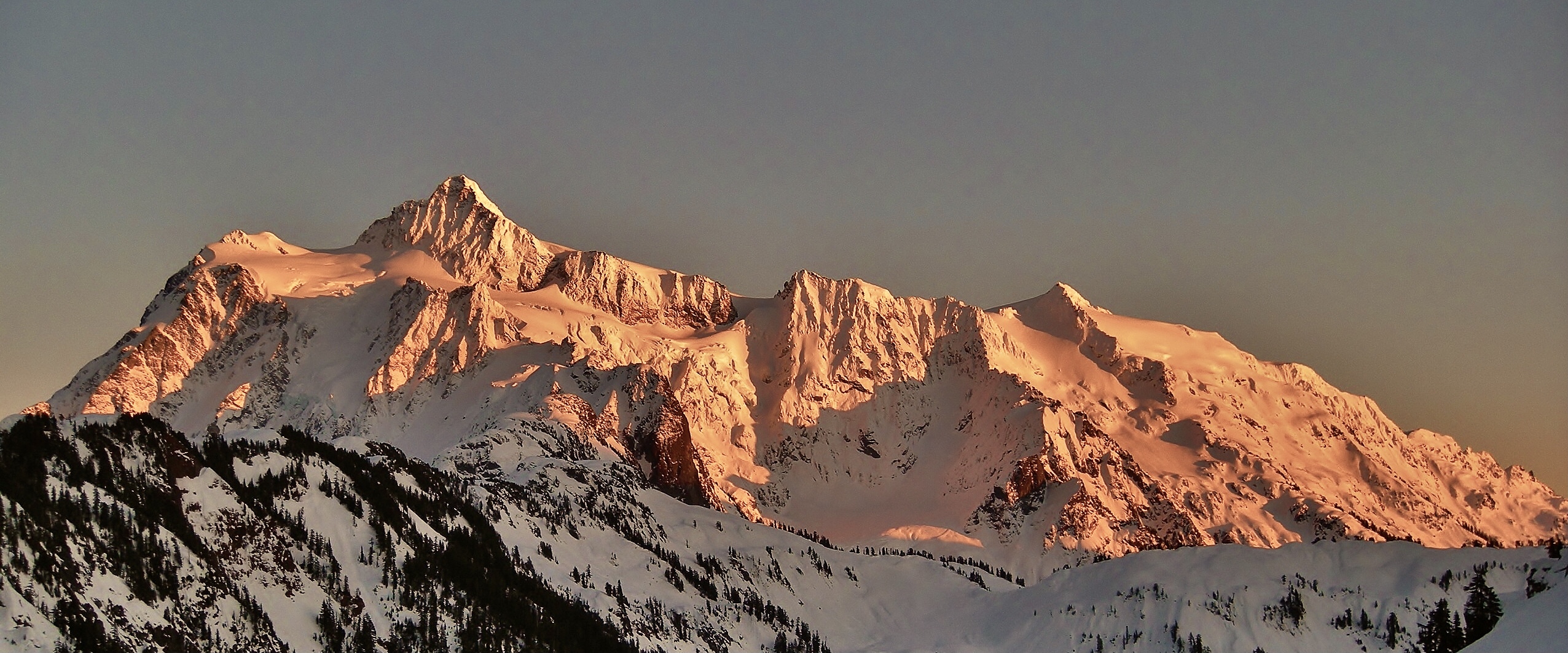
Mt. Baker, Mt. Rainier, Mt. St. Helens, North Cascades, Colchuck Lake, The Enchantments, Mt. Adams, Maple Pass, Mt. Ellinor, Mt. Washington, Sourdough Mountain, Hidden Lake, Skagit Valley, Table Mountain, Cascade Pass, Sahale Arm, Palouse Falls,
This is a great hike with jaw dropping views of N. Cascades including
Mt. Baker, Glacier Peak and Mt. Rainier. If you like the hike of Cascade
Pass/Sahale Arm, this hike will not fail you with sweeping vistas of
amazing landscape and mountain ranges. However, no pain, no gain....be
prepared for a strenuous journey as the trail continuously climbs up and
up, and even gets rocky. Wildflowers are still blooming strong,
particularly paintbrush is abundant at this point. But, summer is
fading....so that could change any time soon.
The lookout is
going through re-roofing now and the work may continue for a week. I
saw two guys (Robert and Ethan) working on the roof. Many thanks for
their work and dedication!....I should have brought them a bottle of
sake for kampai (cheeres)! It made me realize once again the fact that
it does take time and effort to preserve history and wilderness. Hike
up there and witness the history and appreciate their work while
re-roofing is in progress or completed.
Road condition
Cascade
River Road is paved and in great condition. Drive about 10 miles to the
junction/FS 1540. There is a sign for the Hidden Lake Trail. FS1540 is
a narrow dirt road (rutted, rocky, pot holes). So, go slow and take it
easy. My sedan could handle the road with no problem. In 4.5 miles you
reach trailhead. There is one section on the road where it gets really
narrow due to washout, but the spot is well marked with a white stick,
so pay attention as you go....you don't want to drive off the edge!
Trailhead
Parking
lot is small. When you park in the lot or on the road, make sure to
leave enough room for other cars to drive in/out. No privy at
trailhead.
Hidden Lake
The journey begins in the forest and
the trail climbs steadily. In about one mile, views open up as the
treeline thins out and you come to green meadows on the hillside in the
valley. Wow, wildflowers galore! The higher you go, the more flowers
blooming....particularly, paintbrush. The trail continues to climb
steadily with switchbacks for another 1.5 miles or so. As you reach the
saddle, look for Mt. Baker looming over the skyline. The trail levels
out along the saddle. After the breather for 1/2 mile, the trail climbs
up again and gets rocky. The views get better and better as elevation
gains, however. Trekking up the steep and rocky trail about 1.5 miles,
you reach the bottom of the summit block of Hidden Lake Lookout. From
there, zoom in and look for the lookout sitting on a granite boulder
pile at 6,900 feet. What a view! The trail continues to the ridge
where Hidden Lake can be seen down below. There are some snow fields to
traverse about 200 feet or so....it's slushy, but easy to cross. Enjoy
the view of Hidden Lake!....with Forbidden Peak/Boston Peak/Sahale
Arm/Johannesburg in background. Cascade Pass (another amazing hike!) is
somewhere behind Johannesburg, you can visualize.
Lookout
The
trail continues from the viewpoint of Hidden Lake. To reach the
lookout, follow the steep trail climbing up with switchbacks to the
summit. It's pretty steep ascent, but the route is solid with
switchbacks....hopefully, you are not acrophobia!? A little scrambling
and rock hopping are needed for the final push to the lookout.
Wow!
Take in the sweeping vistas in all directions! Splendid! 360 panorama
of jagged N. Cascades peaks with Hidden Lake as foreground, including
Eldorado, Forbidden, Boston Peak, Sahale Mountain, Johannesburg, Spider
Mountain, Mt. Formidable, Snowking Mountain and more. Glacier Peak, Mt.
Baker, and Mt. Rainier are seen in the distance. When you stand on one
of the pointy granite rocks and view those craggy peaks far and near, it
almost makes you feel like you are standing on the Himalayas. It was
also nice to happen to witness the work of re-roofing the lookout. Can
you imagine what it would be like roofing the lookout standing on top of
the granite boulder pile at 6,900 feet?
This hike is
definitely one of the top 10 hikes among my favorites now....not only
spectacular views, landscape, wildflowers and lookout, but also the hike
gives you a sense of the experience of being out in a remote alpine
wilderness. With extra sweat and effort, the reward you'll see is
AWESOME! This is a hike that should be on your hiking list as a PNW
hiker!!
Welcome to a JURASSIC WORLD! Seriously, that was my reaction when I
drove into the parking lot and the breathtaking landscape and scenery
appeared before me....totally "jaw-dropping"! I had read and heard
Cascade Pass hike is one of the top rated and must do hikes of N.
Cascades, and now I believe it....I was totally blown away! With the
trail moderately graded to reach the pass (3.7 miles/1,800' gain), this
hike offers the whole nine yards....spectacular views of peaks and
glaciers, waterfalls, lakes, wildflowers, wildlife and options for
backcountry hikes and camping along with frontier history. I saw many
different kinds of wildlife in this hike....marmots, pikas, chipmunks,
deer, mountain goat and wild birds. If you pick one hike to do in N.
Cascades, this is it! Beyond description. Period.
Road condition
From
SR 20 at Marblemount, drive Cascade River Road for 23 miles to
trailhead. The road is in good condition. You can see some major
restoration works were done after a series of washout. The first half
of the road is paved and the second half is dirt/gravel/washboard. The
road gets narrow and has potholes for the last 6 miles, so pay attention
as you go. Trailhead has a large parking lot with restroom.
Trail condition
Trail
is in great shape in spite of heavy use. It has some wet and muddy
spots here and there, but no major issue. However, if you hike in
sneakers, chances are your feet may get wet. There are a couple of snow
fields to cross near Cascade Pass. One of them is about 100' long on the
steep gully. You can follow the boot tracks, but the snow could get
slushy and slippery. I found my hiking poles helpful to balance. On the
way to Doubtful Lake/Sahale Glacier Camp, there are a few snow fields
(10' - 20' long) to traverse and some of them are forming a snow bridge
with water running underneath. So, use caution when you cross.
Trail/snow condition included in the short video below.
Cascade Pass
Trailhead's
large parking lot fills up fast as this is a very popular destination
for hiking, camping and backpacking. Even it was Thursday, the lot was
pretty full when I arrived after 12/noon....and I saw more cars
arriving. The trail ascends gently for the first 1/2 mile and then
moderately steep grade begins to climb steadily with switchbacks through
the forest. I liked the sound of waterfalls and streams keeping a good
company all along. After 2 miles in, the views open up as the treeline
thins out. Now you are looking at the same breathtaking vista from a
higher vantage point. Stunning! At 3 miles, the trail levels out through
meadows. Wildflowers are blooming! And the views of the jagged
mountains get even better as you go. After the meadows, the trail comes
along the hillside (scree) partially covered with snow. The snow field
to cross is about 100' long and you can follow boot tracks. It may get
slushy/slippery, so just use caution.
Take in the grand
vistas from Cascade Pass. The pass is a gateway to connect different
paths traveling in all directions. Frontier traders used to use the pass
in the past, and today hikers and backpackers (....and wildlife, too!).
Views to north and west are the ragged Cascade range as you see along
the hike. Facing southeast is looking towards Stehekin over 30 miles
away from the pass which is a remote community only accessible on foot,
by ferry or seaplane. In fact, I was in Stehekin 2 weeks ago and had a
great hike there. Looking east, you can see a trail going up towards
Sahale Arm.
Sahale Arm (Sahale Glacier Camp)
You have a few
options for hiking from the pass. You can turn around and head back to
the parking lot, or you can venture towards Stehekin, or continue
another 2 miles/2,100' gain to reach Sahale Glacier Camp. My goal was
to hike up to Sahale Glacier, so I took that route from the pass.
From
the pass, follow the trail sign which says Stehekin. Soon you come to
another sign/intersecion which says Sahale Arm/Stehekin. Go left/Sahale
Arm at the post. The trail to Sahale Arm gets steep and rocky once you
leave Cascade Pass. Some snow fields are en route, but not hard to
cross. Just use caution to traverse the snow field forming a snow
bridge. There are wet and muddy spots along the trail, but no
biggie.....keep "minimum impact" in mind, however, if you have to veer
around. As the trail climbs steadily with switchbacks, the views get
better and better....WOW! You can see Cascade Pass down below with the
great wall of all the jagged mountain peaks facing you.
Trekking
up the hillside for one mile from the pass, you come to the trail sign
of Doubtful Lake. I took a quick look at the lake from above, and
continued on the journey towards Sahale Arm. The trail leads you on to
the saddle stretching up to Sahale. It's beautiful green meadows with
wildflowers.....and also it's a haven for marmots! There are so many
marmots on the meadows. I lost counts how many marmots I saw! They
surprised me as I surprised them!? After passing the meadows, the trail
gets steeper and the scree rockier for the last 1/2 or so. At one
point, the trail disappears and gets a little sketchy due to scree/loose
rocks covering over trail, but there are cairns to guide you to stay on
track.
Enjoy the views from Sahale Glacier Camp! Splendid!
Another WOW moment (how many wows so far?) At 7,600 elevation, you have
sweeping vistas of N. Cascades range and beyond as far as you can
see....and Sahale Arm looms over you across the glacier. Johannesburg
Mountain, Cascade Peak, Magic Mountain, Trapper Mountain, Glory
Mountain, Eldorado Peak, Forbidden Peak, Mount Formidable, Spider
Mountain, LeConte Mountain.....these are the names of the peaks I just
learned with this hike. McGregor Mountain near Stehekin was also seen
in the southern skyline. And, guess who came to greet me out of the
blue? Wow, mountain goat! Five of them....they looked like a
family(?) because I noticed a baby goat with them.
There are
many beautiful hikes in N. Cascades. If I were asked to pick one best
hike among of all, Cascade Pass/Sahale Arm would be the one no doubt.
Put this hike on your hiking list if you haven't hiked it yet. You'll be
blown away! I highly recommend this hike with lots of WOWs. Happy
hiking! :)