Hiking and climbing mountains inspired me into this life philosophy - LIFE IS A MOUNTAIN. Every step you make leads to summit. You may be forced to turn around or change routes for any cause, never know. But, stay focused and look forward. The mountain will be there always. Pace yourself and reach "your" summit, for every step counts. Enjoy the view and feed your soul as it comes along. Life is a journey, not a destination. Life is like climbing a mountain.....
Taft Point Taft Point offers one of the most breathtaking (and it might really take your breath away for its sheer drop!) views of Yosemite Valley. And it's only a little over 1 mile without much elevation gain to get there.
Driving for Glacier Point on Glacier Point Road, just before arriving Glacier Point, there is a parking lot for the Taft Point/Sentinel Dome
The hike is easy for family and kids as well. Just hiking a little over a mile, you can get to see jaw-dropping vistas of the Yosemite Valley with El Capitan and other well-known granite statues of Yosemite. DO NOT stand close to the edge along Taft Point. It's sheer drop! If you are with little children, make sure to keep them stay with you and away from the edge. If you are acrophobia, don't look down.
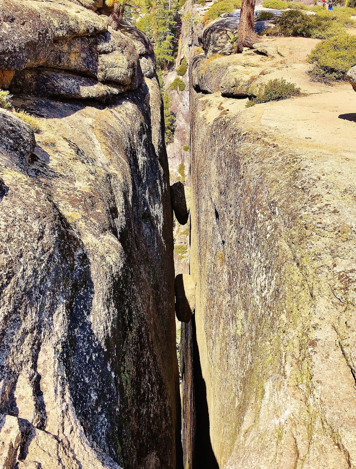
The hike also shows amazing formations of the fissures which visually illustrate the Yosemite Valley's geological formation before your eye. Like Glacier Point, Taft Point can be also best experienced at sunset, overlooking the beauty of El Capitan and the Yosemite Valley.
Sentinel Dome
Sentinel Dome is, perhaps, one of the Yosemite's easiest hikes to experience spectacular panoramic views of the Yosemite Valley in all directions and beyond including peaks of High Sierras and Sierra Crest. When the skies are clear, you can see:
To the west....Yosemite Valley and all the way to the Merced River canyon. To the north....Yosemite Valley with El Capitan, Eagle Peak and Yosemite Falls. To the east....Nevada Fall, Half Dome, North Dome, Clouds Rest, Mt. Watkins and more. To the south....Horse Ridge/Buena Vista Crest in Yosemite Wilderness.
Famous Jeffrey Pine on Sentinel Dome
The dead tree on Sentinel Dome is the Jeffrey pine that became world famous for the 1940 Ansel Adams photo. The tree was killed by drought in 1977 and fell over in 2003. And yet, it still exists there as its legacy continues.
The hike to Sentinel Dome is easy and pleasant like Taft Point although it gets a little rocky part of the way and climbs the moderately steep face of the dome to the top for a short distance.
For an option to combine hiking Taft Point and Sentinel Dome, you can hike along a loop trail connecting Taft Point and Sentinel Dome instead of making back and forth hikes to the trailhead to do both hikes. The loop trail travels facing to the Yosemite Valley off and on with stunning views of the Yosemite Valley....and the trail is less crowded and quieter if you prefer. You can also hike to Glacier Point from Sentinel Dome in 1.6 miles.
Trailhead - Pyramid Creek/Twin Bridges on US 50 5 miles (?) RT 800+ (?) Elevation gain
This is a very popular hike along HWY 50 on the way to South Lake Tahoe. It is a short hike, but the trail climbs steeply toward the magnificent Horsetail Falls. The trail may get a bit sketchy where you traverse those giant granite slabs, but generally easy to follow along the trail. There are many short trails branching out to the creek from the main trail, so don't get confused or lost. Most hikers end their journey at the bottom of the falls unless you are confident enough
to scramble the steep rock slabs to the top of the falls. If you are to tackle the way up to the top, use caution as those granite slabs can be very slippery because of the splashing water from the falls. Also, route finding skills are a must as there is no well established route to reach all the way to the top.
As informed by the rangers at the trailhead, the route I was advised to take to the top of the falls was climbing to the left from the big granite slab where you come to choose either go to the right or to the left. Going to the right can be very slippery. Scrambling up to the left eventually leads you to a partially established trail through screes/talus rocks and boulders and in time and effort gets you to the top. Some scrambling necessary, however. There are cairns along the route which also help and guide you on the way up to the top and on the way to come down.
Enjoy the views of the Horsetail falls from above! Magnificent and powerful falls. You can trek around Avalanche Lake to explore the alpine wilderness. If you are backpacking, Avalanche Lake will be a perfect site for overnight, or you can continue to hike farther deep into Desolation Wilderness if you are an experienced backpacker.
This is a long day hike/15 miles RT from Echo Lake passing 5 alpine lakes to reach Lake Aloha - a prime swimming spot of beautiful Desolation Wilderness. The hike to Lake Aloha is a must do hike in Desolation
Wilderness to experience what Desolation Wilderness offers....alpine lakes, wildflowers, wildlife, alpine peaks and a remote sense of wilderness.
The trail is mostly flat through the hike with some sections of elevation gain, and also gets rocky part of the way. You will pass by 5 lakes
in this hike. Enjoy the views of the alpine lakes....and swimming if you like! I saw hikers sunbathing, napping and of course, swimming in the lake(s)....there is no
better way to relax than swimming after a long hike in a hot summer day! Lake Aloha is gorgeous with pristine water surrounded by alpine boulders and picturesque peaks. It's a great place for camping and backpacking so that you can explore the area more leisurely.
For a side trip, I recommend to stop by Lake of the Woods located near Lake Aloha. You can hike there on the way to/from Lake Aloha as the trail sign directs.
This is a great hike to experience Desolation Wilderness with spectacular views. Maggies Peaks are one of the gateways to Desolation Wilderness. There is no official trail going up to Maggies Peaks from the main trail/Bayview Trail, but you can follow boot tracks to the peaks once you reach the saddle and aim to climb towards the top. Keep "minimum impact" in mind, however, and not to trek over and damage vegetation. Maggies south peak offers a fantastic panoramic view of Lake Tahoe, Emerald Bay, Cascade Lake, Fallen Leaf Lake and South Lake Tahoe with surrounding Tahoe rim and Carson range peaks - Mt. Tallac, Freel Peak, Jobs Peaks, Mt. Rose and more. From Maggies north peak, you can peek into the remote alpine environment of Desolation Wilderness.
I continued the journey to Dicks Lake from Maggies Peaks via Bayview Trail and took the same route back to the trailhead. You can take side trip options for Velma Lake and/or Eagle Lake en route to/from Dicks Lake, which will add extra distance and time to the journey.
Welcome to a JURASSIC WORLD! Seriously, that was my reaction when I
drove into the parking lot and the breathtaking landscape and scenery
appeared before me....totally "jaw-dropping"! I had read and heard
Cascade Pass hike is one of the top rated and must do hikes of N.
Cascades, and now I believe it....I was totally blown away! With the
trail moderately graded to reach the pass (3.7 miles/1,800' gain), this
hike offers the whole nine yards....spectacular views of peaks and
glaciers, waterfalls, lakes, wildflowers, wildlife and options for
backcountry hikes and camping along with frontier history. I saw many
different kinds of wildlife in this hike....marmots, pikas, chipmunks,
deer, mountain goat and wild birds. If you pick one hike to do in N.
Cascades, this is it! Beyond description. Period.
Road condition
From
SR 20 at Marblemount, drive Cascade River Road for 23 miles to
trailhead. The road is in good condition. You can see some major
restoration works were done after a series of washout. The first half
of the road is paved and the second half is dirt/gravel/washboard. The
road gets narrow and has potholes for the last 6 miles, so pay attention
as you go. Trailhead has a large parking lot with restroom.
Trail condition
Trail
is in great shape in spite of heavy use. It has some wet and muddy
spots here and there, but no major issue. However, if you hike in
sneakers, chances are your feet may get wet. There are a couple of snow
fields to cross near Cascade Pass. One of them is about 100' long on the
steep gully. You can follow the boot tracks, but the snow could get
slushy and slippery. I found my hiking poles helpful to balance. On the
way to Doubtful Lake/Sahale Glacier Camp, there are a few snow fields
(10' - 20' long) to traverse and some of them are forming a snow bridge
with water running underneath. So, use caution when you cross.
Trail/snow condition included in the short video below.
Cascade Pass
Trailhead's
large parking lot fills up fast as this is a very popular destination
for hiking, camping and backpacking. Even it was Thursday, the lot was
pretty full when I arrived after 12/noon....and I saw more cars
arriving. The trail ascends gently for the first 1/2 mile and then
moderately steep grade begins to climb steadily with switchbacks through
the forest. I liked the sound of waterfalls and streams keeping a good
company all along. After 2 miles in, the views open up as the treeline
thins out. Now you are looking at the same breathtaking vista from a
higher vantage point. Stunning! At 3 miles, the trail levels out through
meadows. Wildflowers are blooming! And the views of the jagged
mountains get even better as you go. After the meadows, the trail comes
along the hillside (scree) partially covered with snow. The snow field
to cross is about 100' long and you can follow boot tracks. It may get
slushy/slippery, so just use caution.
Take in the grand
vistas from Cascade Pass. The pass is a gateway to connect different
paths traveling in all directions. Frontier traders used to use the pass
in the past, and today hikers and backpackers (....and wildlife, too!).
Views to north and west are the ragged Cascade range as you see along
the hike. Facing southeast is looking towards Stehekin over 30 miles
away from the pass which is a remote community only accessible on foot,
by ferry or seaplane. In fact, I was in Stehekin 2 weeks ago and had a
great hike there. Looking east, you can see a trail going up towards
Sahale Arm.
Sahale Arm (Sahale Glacier Camp)
You have a few
options for hiking from the pass. You can turn around and head back to
the parking lot, or you can venture towards Stehekin, or continue
another 2 miles/2,100' gain to reach Sahale Glacier Camp. My goal was
to hike up to Sahale Glacier, so I took that route from the pass.
From
the pass, follow the trail sign which says Stehekin. Soon you come to
another sign/intersecion which says Sahale Arm/Stehekin. Go left/Sahale
Arm at the post. The trail to Sahale Arm gets steep and rocky once you
leave Cascade Pass. Some snow fields are en route, but not hard to
cross. Just use caution to traverse the snow field forming a snow
bridge. There are wet and muddy spots along the trail, but no
biggie.....keep "minimum impact" in mind, however, if you have to veer
around. As the trail climbs steadily with switchbacks, the views get
better and better....WOW! You can see Cascade Pass down below with the
great wall of all the jagged mountain peaks facing you.
Trekking
up the hillside for one mile from the pass, you come to the trail sign
of Doubtful Lake. I took a quick look at the lake from above, and
continued on the journey towards Sahale Arm. The trail leads you on to
the saddle stretching up to Sahale. It's beautiful green meadows with
wildflowers.....and also it's a haven for marmots! There are so many
marmots on the meadows. I lost counts how many marmots I saw! They
surprised me as I surprised them!? After passing the meadows, the trail
gets steeper and the scree rockier for the last 1/2 or so. At one
point, the trail disappears and gets a little sketchy due to scree/loose
rocks covering over trail, but there are cairns to guide you to stay on
track.
Enjoy the views from Sahale Glacier Camp! Splendid!
Another WOW moment (how many wows so far?) At 7,600 elevation, you have
sweeping vistas of N. Cascades range and beyond as far as you can
see....and Sahale Arm looms over you across the glacier. Johannesburg
Mountain, Cascade Peak, Magic Mountain, Trapper Mountain, Glory
Mountain, Eldorado Peak, Forbidden Peak, Mount Formidable, Spider
Mountain, LeConte Mountain.....these are the names of the peaks I just
learned with this hike. McGregor Mountain near Stehekin was also seen
in the southern skyline. And, guess who came to greet me out of the
blue? Wow, mountain goat! Five of them....they looked like a
family(?) because I noticed a baby goat with them.
There are
many beautiful hikes in N. Cascades. If I were asked to pick one best
hike among of all, Cascade Pass/Sahale Arm would be the one no doubt.
Put this hike on your hiking list if you haven't hiked it yet. You'll be
blown away! I highly recommend this hike with lots of WOWs. Happy
hiking! :)
Wildflowers galore! All sorts of wildflowers are blooming along the
green meadows in this hike and I've never seen so many tiger lilies all
over. And, yes, indeed, Green Mountain is so GREEN!! The name of the
mountain speaks for itself.
What a beautiful hike! Is Green
Mountain sort of like a hidden gem? I am not sure how popular or well
known this hike is, but it is GORGEOUS!....from
wildflowers/creeks/tarns/meadows to sweeping mountain views of N.
Cascades/Glacier Peak/Mt. Baker ranges in all directions including as
far as the Puget Sound. I am so glad I found this hike thanks to WTA's
trip description and recent trip reports. The lookout, built in 1933,
still exists on top of Green Mountain. It's listed on the National
Register of Historic Places and restoration is ongoing. When you see
jaw-dropping 360 panorama from the summit and understand the terrains of
the groups of the surrounding peaks, ranges and geography, it makes
sense why the lookout was built on top of Green Mountain.
Road condition
FR
26 (Suiattle River Road) is in great condition. From SR 530, follow FR
26 about 20 miles to FR 2680. The first half of FR 26 is paved and the
second half is dirt/gravel (it looks and feels like paved, however).
From FR 26, drive FR 2680 about 6 miles to trailhead. FR 2680 is a
narrow and rough road (bumpy and rocky), but not too bad. My 4 door
sedan could handle it with no problem. Just go slow and take it easy.
Road condition included in the short video clip below.
Green Mountain Trail
The
trail climbs gently through the old growth of the timberline for the
first 1/2 mile or so, and then gets moderately steep until the view
opens up at 1 mile and you come into green meadows on the slope of the
mountain. Wow, it's so GREEN!....it's like a thick green velvet
covering the mountain. The meadows are alive with so many wildflowers
you can imagine along the trail. They are also quite entertaining with
different varieties, colors and smells....never monotonous!
Particularly, I really enjoyed tiger lilies because I've never seen that
many tiger lilies bursting all over. By the way, part of the trail
through the meadows gets brushy with waist high vegetation, so wearing
long pants may be recommended if you are one of those who don't like to
be brushed by plants.
After ascending the green meadows filled
with wildflowers, at 2.5 miles you descend to a little valley and the
trail passes a tarn and crosses a creek. There is a big blowdown
blocking the trail soon after the tarn, but you can cross over it by
veering to right or left. After that, you come to vast open meadows
surrounded by green mountains...wow! From there you can see Green
Mountain's summit and spot the lookout standing on the top. In the
meadows I noticed glacier lilies were just about to bloom
soon.....budding.
The last mile to the top is quite steep with
switchbacks. There are some snow patches, but they are small and easy
to cross. Pace yourself and enjoy the views as you ascend. Yesterday the
air was cool with a gentle breeze, so, luckily, heat or sweat didn't
become an issue. Make sure to stay hydrated if you trek this steep
section on a warm sunny day. Sunscreen and hat will be also handy.
Take
in the jaw-dropping views from the top. Green Mountain is so GREEN! You
have breathtaking sweeping vistas in all directions....N. Casacdes, Mt.
Baker, Glacier Peak, and all other peaks near and far, and to the west
is the Puget Sound! It was interesting to be able to see those local
peaks along the Mountain Loop HWY side by side....Pilchuck, White Horse,
Three Fingers, Pugh, Big Four, Dickerman and others. The outlook is
closed, but you can enjoy views from the deck. It is amazing to see the
old structure still standing proudly on top of the peak since 1933.
Green
Mountain is one of the loveliest hikes I found in the N. Cascades. I am
very glad I hiked when it is GREEN! Go soon if you want to see the
"green" mountain in bursting wildflowers....and pick a clear day for
spectacular views from the top. Happy hiking!
Two thumbs up! Amazing hike. In just a little over 1 mile/1000' gain,
this hike offers sweeping vistas of breathtaking mountains, green
valley, lakes, wildlife and the towering peaks of Tatoosh range -
Pinnacle Peak, the Castle, Plummer Peak, Denman Peak, Unicorn
Peak....and more beyond near and far....plus, great workout. You may
say, "really?" And, my answer is YES!!
I always wondered if
there was a way to hike up to those peaks sticking out on Tatoosh range
seen from Paradise. To me, they always remind me of Gothic cathedrals
visually. Last month when I hiked to Unicorn Peak, someone told me
there is a short and easy trail to Pinnacle saddle. Since then, I put
Pinnacle saddle on my hiking list. When I read the recent trip report
on the hike describing the route is snow free and in good condition, my
spirit said "let's go!"
Pinnacle Saddle
Trailhead is
located right by Reflection Lakes across Stevens Canyon Road. Follow
the trail sign which says Pinnacle Peak Trail. The trail starts with a
gentle grade and soon climbs steadily. Snow along the trail is almost
all gone and there are some small patches left here and there. Glacier
lilies are abundantly blooming now in lower elevations and will be
bursting all over pretty soon. The trail is in excellent condition, but
partially a little wet, which is normal this time of the season as snow
is still melting. There is a couple of long stretches of snow still
standing en route in about between 0.5 - 1 mile from trailhead. But,
they are not hard to cross as the snow is firm and not slippery, and
boot tracks are solid. There are a few gullies to traverse en route,
and they have some snow, but no problem to cross. One of the gullies
has snow and scree (loose rocks) on the path and it was a little tricky
as the scree created loose traction. So, pay attention as you proceed.
In
1.3 miles, you reach Pinnacle saddle....the portal to many amazing
views and hikes! The trail sign says "End of maintained trail." Wow,
where is the amazing views?" Mt. Rainier? Pinnacle Peak? Unfortunately,
clouds were forming when I started the hike and by the time when I
reached the saddle, it was totally shrouded in the clouds! Darn
it....no views?...you've gotta be kidding!? I stepped over to the other
side (south) of the saddle.... Mt. Adams was faintly visible through
the clouds. But, wait....I could slightly see some blue skies to the
east through the clouds!
Pinnacle Peak/the Castle
You have a
couple of options for hiking from the saddle. Climbers routes run from
the saddle....going right (west) for Plummer Peak and going left (east)
for Pinnacle Peak and the Castle. Because I saw some blue skies to the
east, I decided to take the trail to east and hike toward Pinnacle
Peak/the Castle.
Bingo! The view gradually opened up in blue
skies as I came out of the shroud of the clouds. Wow, amazing vistas
before my eyes!....the Castle, Mt. Adams, Denman Peak, Plummer Peak,
green meadow and valley (Butter Creek Research Natural Area) down below,
wildflowers....and Pinnacle Peak looms right beside! In fact, the
clouds shrouding part of the valley and surrounding peaks created a
mystic beauty of austerity....adversity became advantage.
The
climbers route to Pinnacle Peak/the Castle is not too bad. It's dirt,
scree and rocks with a little up and down and over all in good shape.
There are a couple of sketchy sections en route, but not hard to figure
out the way. In about 1/3 mile from the saddle, you come to the point
where you may need to decide....either ascend the scree slope to the
ridge between Pinnacle and the Castle, or continue the trek toward the
Castle, or turn around. It looks there are several different routes and
options to choose from there, based on what you aim for with Pinnacle
Peak and the Castle. Assessing my capability (I am NOT a rock climber
or a hard core scrambler!) and visually evaluating visible traces of
routes and other factors (grade, scree, rocks), I decided to climb
straight up to a short ridge close to the west face of Pinnacle Peak,
instead of hiking further toward the Castle. I was hoping for open
vistas to north from the ridge. Ascending the steep route to the ridge
was a little tricky due to loose scree, but manageable. A little
scrambling near the ridge may be needed....I used my hands to grab the
rocks. Overall, the route I took was secure and no serious climbing
skills were necessary.
Take in the majestic view of Mt.
Rainier! It's the best view of Rainier I've seen among all my Rainer
hikes so far. The sea of clouds added a magical beauty no doubt. It
gave me goose bumps all over. No joke! Pinnacle Peak looms right beside
me and the Castle rises just to west from me. We juxtaposed all
together there. Totally amazing. Beyond words. The view south was
equally spectacular....Mt. Adams, Unicorn Peak, Denman Peak, Plummer
Peak....and Mount St. Helens joined the skyline, too.
If you
want amazing views for a short hike, I highly recommend the hike to
Pinnacle saddle on a clear day. You can also explore part of climbers
routes for additional adventures, either with Plummer Peak or Pinnacle
Peak/the Castle. If you are a climber, you already know what you are
looking for! I'd like to go back again to hike up to Plummer Peak next
time.