Freel Peak
(10,881’), CA
September
2, 2010
Trout
Creek Trailhead: 11 miles RT
Elevation
gain - 3,680’
 Take I-50 to S. Lake Tahoe. After I-50 and HWY 89 merge, take
right onto Pioneer Trail; then, right onto Oneidas Street. The trailhead is
about 4 miles up the road. There is a gate at the end of Oneidas Street. Near
the gate there is a sign which says “Freel Peak”. Trail is easy to follow up to
Armstrong Pass where you come to a 4 way intersection….south to Big Meadow,
west to Fountain Place and Pioneer Trail (where you come from), and north
towards Star Lake and Kingsbury. Follow the sign to Star Lake and trek up to
reach the saddle at the junction of Tahoe Rim Trail and Freel Peak Trail, which
takes you to the Freel summit.
Take I-50 to S. Lake Tahoe. After I-50 and HWY 89 merge, take
right onto Pioneer Trail; then, right onto Oneidas Street. The trailhead is
about 4 miles up the road. There is a gate at the end of Oneidas Street. Near
the gate there is a sign which says “Freel Peak”. Trail is easy to follow up to
Armstrong Pass where you come to a 4 way intersection….south to Big Meadow,
west to Fountain Place and Pioneer Trail (where you come from), and north
towards Star Lake and Kingsbury. Follow the sign to Star Lake and trek up to
reach the saddle at the junction of Tahoe Rim Trail and Freel Peak Trail, which
takes you to the Freel summit.
*Click to view large.


People may not have
heard of this peak. In fact, I didn’t
know until my friend told me about it. Located at the south end of the Carson
Range, which runs north to south along the east side of Lake Tahoe, Freel Peak
(10,881’) is the highest point of Tahoe basin. It may have less hiking traffic
compared to other popular hikes such as Mount Tallac and Mount Rose. The hike
is rather strenuous; gaining 3,680’ in 5 miles into the elevation 10,881’ is more
than just a workout. It will physically challenge you to conquer Freel Peak, no
doubt. There are two other peaks right next to Freel Peak - Jobs Sister and
Jobs Peak, and a triple summit of Tahoe basin’s high points in one day is
possible: Freel Peak (10,881’ - highest of the Tahoe basin); Jobs Sister
(second highest - 10,823’); and Jobs Peak (fourth highest - 10,673’). I started
my hike a little late, getting to the trailhead around 3pm because of an
unexpected road work on the way. Trailhead
is easy to find and the trail is well maintained, though you have to share with
mountain bikers. Gradual ascent through the forest gives a great opportunity to
enjoy the tree lines of Lodgepole pine, Red fir and Whitebark pine. The last 1
mile to the summit is quite challenging…..steep and sandy trail above 10,000’.
If you plan to summit Freel Peak in summer, bring enough water to stay
hydrated, or you will regret….it gets pretty hot and dry. The 360 degree view from the top of Freel Peak
is well worth for the effort. Vistas from the summit at 10,881’ are
breathtaking. I didn’t have enough time to explore Jobs Sister and Jobs Peak
this time. I’ll save it for the next
time….triple summit.
How
to get there:
 Take I-50 to S. Lake Tahoe. After I-50 and HWY 89 merge, take
right onto Pioneer Trail; then, right onto Oneidas Street. The trailhead is
about 4 miles up the road. There is a gate at the end of Oneidas Street. Near
the gate there is a sign which says “Freel Peak”. Trail is easy to follow up to
Armstrong Pass where you come to a 4 way intersection….south to Big Meadow,
west to Fountain Place and Pioneer Trail (where you come from), and north
towards Star Lake and Kingsbury. Follow the sign to Star Lake and trek up to
reach the saddle at the junction of Tahoe Rim Trail and Freel Peak Trail, which
takes you to the Freel summit.
Take I-50 to S. Lake Tahoe. After I-50 and HWY 89 merge, take
right onto Pioneer Trail; then, right onto Oneidas Street. The trailhead is
about 4 miles up the road. There is a gate at the end of Oneidas Street. Near
the gate there is a sign which says “Freel Peak”. Trail is easy to follow up to
Armstrong Pass where you come to a 4 way intersection….south to Big Meadow,
west to Fountain Place and Pioneer Trail (where you come from), and north
towards Star Lake and Kingsbury. Follow the sign to Star Lake and trek up to
reach the saddle at the junction of Tahoe Rim Trail and Freel Peak Trail, which
takes you to the Freel summit.

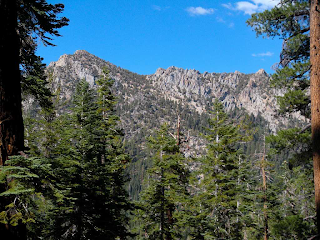
First hike through tree
lines until Armstrong Pass. Trees that dominate tree lines are Lodgepole pine,
Red fir, and Whitebark pineand they are typical in Tahoe Sierra. Trail is
well-maintained and easy to follow, and it’s also a bike
trail. Castle-like steep
crags stand out along the saddle - Trimmer Peak.


Armstrong Pass where the
4 way intersection is……south to Big Meadow, west to Fountain Place and Pioneer
Trail/Trout Creek trail (where I hiked from), or north towards Star Lake and
Kingsbury. This is a halfway point to the summit if you hike from west (Trout
Creek trail).


Fountain Face…dramatic rock
formations on the west slope of Freel Peak. Fountain Place…green meadow
below the trail. Both were named after Garret Fountain, who built a way station
at Fountain Place in 1860. He thought that Armstrong Pass would be the chosen
gateway through the mountains for the miners from CA to Comstock Lode (Virginia
City), NV., hoping that he could make some good business from the traveling
traffic. However, Armstrong Pass never became a popular pass because Comstock
Lode mine operators financed to build Daggett Pass (the present Kingsbury Grade
Rd = SR 207), about 8 miles north of Freel Peak instead. Fountain’s ambition was never fulfilled. No
buildings remain at Fountain Place today.


Creek crossing, waterfall and wildflower.


This
is where the two trails
meet…the trail from Armstrong Pass and the other from Tahoe Rim Trail
approaching from north. The pic (above) shows the view north of Monument
Pass and Monument Peak (10,067’), and Lake Tahoe is visible. Monument
Peak is home of Heavenly Ski Resort.
The sign says 1 mile to the summit.
Above 10,000', vegetation thins out and the trail gets sandy and kicks your butt!


Freel Peak summit - 10.881'. Sunset view of Lake Tahoe.
Mt. Rose (10,776') is visible (far right).

Jobs
Peak in front, Freel Peak casting its shadow against the sky.

Kirkwood and Sierra Nevada and Crystal Range (Desolation Wilderness) in skyline. On a clear day, Yosemite
Valley can be seen in distance.
No comments:
Post a Comment