Showing posts with label mountain. Show all posts

Saturday, January 29, 2022

Hiking Mt. Karamatsu 唐松岳


Hiked on 9/15/2021


Mt. Karamatsu, known as Karamatsu-dake(唐松岳) is located in Hakuba, Nagano prefecture, where the 1998 Winter Olympic Games took place.


A couple of ski lifts take you up to trailhead/Happoike Sanso at 1850m. For RT it takes about 7hrs with 850 meter elevation gain and loss. The hike offers a pristine alpine lake, seasonal wildflowers, fall folisge and wildlife such as Ptarmigan, known as Raichō(雷鳥) and Japanese Macaque monkey Nihonzaru(ニホンザル).


Mt. Karamatsu is a great day hike to explore and get a taste of the Northern Alps of Japan with breathtaking landscape, mountain peaks, pristine alpine lakes and beautiful nature in all directions. 👍👍


Japanese macaque monkey(ニホンザル):

I wasn’t really expecting monkeys with this hike, but came across quite a few of them en route as they were coming and going across the trail here and there. It was like playing “hide and seek” along the trail with them! 😅🐵🐒


Stats(approx.):

Distance: 10km/6.2miles

Gain: 850m/2,789'

Summit: 2,696m/8,845’

Time: 7hr RT


Camera: iPhone 8


Video by Lifeisamt


Wednesday, July 19, 2017

Meiss Meadow Wildflowers & Red Lake Peak Via PCT - Carson Pass, CA


7/16/2017


Hills are alive with wildflowers! This hike will remind you of a picturesque scenery from the film The Sound Of Music....wildflowers in lush alpine meadows with snow melting mountain views. Wildflowers are abundant along the trail and get better as you go and up higher.

Timing is everything. If your timing is right, you can see beautiful wildflowers in many places along the way.....phlox, lupine, mules ears, paintbrush, penstemon and more. About 1.5 miles in, you pass a high meadow at the foot of Red Lake Peak, where patches of Irises are displaying nicely, some blue and some white.

Red Lake Peak (10,068')
Instead of hiking down toward Meiss Lake and Showers Lake, I ventured out to climb Red Lake Peak (10,068') from which John C. Fremont and Charles Preuss made the first recorded sighting of Lake Tahoe during Fremont's expedition in February 1844. There is a lake (Red Lake) just east of Carson Pass for which the peak is named.  Along with Lake Tahoe, views from the top are spectacular in all directions....Hope Valley, Round Top Peak, the Sisters, Elephants Back, and Mokelumne Wilderness and beyond to the south; to the north are Freel Peak, Jobs Sisters and Desolation Wilderness peaks as well as Meiss Meadow, Little Round Top and Caples Lake to the west.

Carson Pass
Carson Pass was a historic pass during the California Gold Rush and PCT traverses the pass. Carson Pass also has a California Historical Landmark (#315) where Kit Carson carved his name into a tree. Kit Carson was a guide to lead the 1844 Fremont Expedition.


Round Top Peak Via PCT Winnemucca Lake - Carson Pass, CA


7/12/2017


Pristine alpine lakes, creeks, lush valley, forest and mountain views with displays of colorful summer's wildflowers, wow! This hike has it all. Amazing hike to Round Top Peak with gorgeous views and wildflowers via PCT - Winnemucca Lake from Carson Pass. As of July 12, the first mile or so from Carson Pass trailhead is snow free, and thereafter patches and fields of snow still remain here and there along the trail. The route to Round Top Lake and Round Top Peak is still under snow/2 - 3 feet deep. The saddle to the summit is snow free.

Wildflowers galore!....Tahoe mule ears, paintbrush, lupine....just name a few.  Many wildflowers are blooming along the trail, particularly by Winnemucca Lake. Also, around Frog Lake. 

Round Top Peak (10,381') is one of the three prominent peaks above 10,000 feet in Lake Tahoe region. The other two are Freel Peak(10,881') and Mt. Rose (10,776'). The easiest approach to summit is from the west ridge and Class 2 scrambling to the top. The route to the saddle is steep and still snow covered and slushy/slippery, so hiking poles and micro-spikes are useful if you aim to summit anytime soon. Enjoy sweeping views from the top in all directions! Be careful at the top as the summit is small and narrow.

Carson Pass was a historic pass during the California Gold Rush and PCT traverses the pass. Carson Pass also has a California Historical Landmark (#315) where Kit Carson carved his name on a tree. Kit Carson was a guide to lead the 1844 Fremont Expedition.

There were quite a few PCT thru hikers seen on trail traveling north. Wish them safe journey and good luck!

Carson Pass Information Center at trailhead....stop by for update info, permit, fees. The staff are very helpful.


Video by Lifeisamt

Thursday, January 19, 2017

Mt. Hoffman via May Lake - Yosemite National Park, CA

October 11, 2016


Distance:  2.5 miles RT to May Lake; 6 miles RT to Mt. Hoffmann 
Trailhead:  May Lake High Sierra Camp/8,710 feet  
Elevation Gain:  500 ft to May Lake/9,270 ft; 2,000 ft to Mt. Hoffman/10,845 ft 

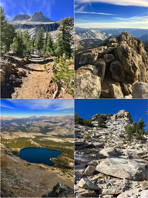
Summit Mt. Hoffman via May Lake in Yosemite's high country along Tioga Road. Great 360 views from the top. Mt. Hoffman looms as Yosemite's geographical center. Hiking to May Lake is straight forward and easy, but the journey from the lake to Mt. Hoffman is moderate to advance as the trail gains elevation steeply and requires route finding skills part of the way while the route becomes rocky and sandy.  Follow cairns to stay on track.  The reward is worth the effort when you see the breathtaking views from the top....360 panorama of Yosemite's High Sierra ranges and May Lake's crystal blue water. Bring enough water to stay hydrated if you do this hike in summer.