Showing posts with label High Sierra. Show all posts

Friday, October 13, 2017

Clouds Rest 9/28/2017 - Yosemite NP, CA


9-28-2017

Clouds Rest offers one of the most breathtaking 360 panoramic views in Yosemite Valley as it gives the best vantage point of the valley.  The hike also provides quite an impressive and thrilling experience as you traverse the narrow ridge with sheer drop-offs on both sides to reach the summit. The fastest and shortest way to scale Cloud's Rest is from the Sunrise Lakes trailhead on Tioga Road near Tenaya Lake. 

From the trailhead, follow the trail sign for Sunrise H.S.C. After the first 1.5 mile, the trail starts to climb steeply in switchbacks. The switchbacks will get your heart rate going no doubt as you gain 1,000' in just one mile. No pain, no gain! Go easy and be careful as you cross the narrow ridge to the top...both sides of the sharp ridge are sheer drop-offs.

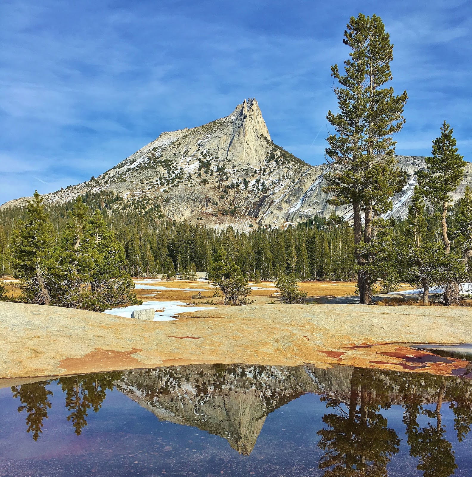
Take in amazing vistas from the summit...many of Yosemite landmarks such as Half Dome, Mt. Hoffman, Mt. Dana, Sentinel Dome, North Dome, Tenaya Lake, Cathedral Rock and El Capitan...and many peaks of High Sierras.

There were rockfalls at El Capitan two days in a row. The second rockfall at El Cap was seen in this hike from the top of Clouds Rest.


Video by Lifeisamt


El Capitan's Second Rockfall Seen From Clouds Rest 9/28/2017 - Yosemite NP, CA

3:22 PM, 9/28/2017


9-28-2017

El Capitan's massive rockfall occurred for second straight day, Thursday, Sept. 28, 2017, in Yosemite National Park. A gigantic granite slab fell from the east wall of El Capitan. I was hiking up Clouds Rest on Thursday and happened to see the rockfall covering the valley with a cloud of dust.  

It's a sobering reminder that the landscape is constantly changing even though it may not seem like that.


Video by Lifeisamt


3:19 PM
3:20 PM
3:22 PM
3:25 PM
3:25 PM
3:25 PM
3:28 PM
3:29 PM
3:34 PM
3:34 PM
3:34 PM
3:35 PM
3:37 PM
3:44 PM


Thursday, September 21, 2017

Hike up Kearsarge Pass to Kearsarge Lakes 9/16/2017 - Onion Valley, CA


9/16/2017


Amazing hike with a series of alpine lakes, waterfalls and towering mountain peaks of High Sierra. Kearsarge Pass (11,760') is one of the most direct and shortest routes connecting eastern and western High Sierras. Kings Canyon National Park is situated just on the other side (west) of the pass. This 5 mile long hike gaining 2,660' elevation provides spectacular mountain vistas all along the journey. Kearsarge Pass Trail traverses John Muir Wilderness and connects with John Muir Trail and PCT. 

From the beginning of the hike at Onion Valley trailhead, breathtaking views amaze you. Trail is well maintained and climbs in switchbacks. Along the trail there are a series of waterfalls and alpine lakes....Little Pothole Lake, Gilbert Lake, Flower Lake, Heart Lake and Big Pothole Lake. University Peak (13,589'), which is named for the University of California, looms over the lakes as you go, and Mt. Gould (13,012') comes in sight as you approach the pass. 

Take in breathtaking views from the pass....to the west are peaks and lakes of the King-Kern Divide in Kings Canyon NP, whereas Kearsarge Pinnacles and Kearsarge Lakes dominate the foreground. To the south, University Peak towers along the jagged ridge running from the pass with Big Pothole Lake sitting just below the pass. Zoom in grand vistas down towards the east, and Onion Valley and Independence/HWY395 are visible. 

Kearsarge Pass Trail offers such a breathtaking scenery of the Sierra Crest landscape with high mountains and alpine lakes in relatively easy and short hike. Two thumbs up!


 Video by Lifeisamt


Wednesday, August 2, 2017

Pyramid Peak Via Rocky Canyon Trail - Desolation Wilderness, CA


Pyramid Peak seen from Ralston Peak 6-30-2017


July 30, 2017


When I hiked into Lake Aloha in Desolation Wilderness last year, I saw a pyramid-like granite mountain towering over the lake. It was Pyramid Peak I saw for the first time. I was so fascinated by the shape of the peak just like a pyramid and wondered if there was any trail going up to the top. Later I learned Rocky Canyon trail was the most direct and shortest approach to summit. This June when I hiked up Ralston Peak and faced Pyramid Peak for the second time, I set my eyes on Pyramid.

Scaling Pyramid Peak via Rocky Canyon trail is the most vertical climb in the Tahoe Sierra, gaining 4,100' elevation in 3.5 miles reaching the summit at 9,983'. That said, the journey is challenging and strenuous. However, the reward at the end is worth the effort, that is, a spectacular view in all directions into Desolation Wilderness and beyond....Crystal Range, Lake Aloha, Desolation Valley, Lake Tahoe, Carson Range, peaks of Carson Pass and beyond as far as you can see. Also, Wildflowers are blooming in meadows and I saw a wilderness resident....marmot!

Trailhead
There is no official trailhead for this hike. Park your car along highway 50 heading east about a mile after passing Strawberry Lodge. There is a small dirt pullout for several cars near the overhead traffic info board. If it's full, park along the road, but beware of "no parking" sign.

The entry point to the trail is across the road from the old 43 mile stone marker. There's also a big rock obscurely painted in gray at the point where you make a short climb up to the trail. Once you climb up the embankment, soon you'll see the obvious trail.

Journey
The trail is in good condition overall and climbs steeply from the beginning and crosses a creek in about a mile. There are many blowdowns along the trail, so you have to cross over or veer around them. Follow cairns as you go, so you can stay on the route. If you end up bushwhacking along the way, you are likely not on the right track. The forest gradually thins out after crossing the creek and you come to meadows where the trail levels out...wildflowers are blooming nicely. After the meadows, the trail gets steep again and Pyramid Peak comes in sight. There are some snow fields along the trail, but it's easy to cross. The trail becomes a scree slope and climbs steeply in switchbacks along the southeast ridge of Pyramid Peak. Pace yourself with high altitude/9,000'+ and make a final push through talus rocks to the summit. Be careful as you ascend the talus slope....rock and boulder hopping. Make sure your footing and hand holds are secure and stable on the rock. Take in amazing vistas from the top. Two thumbs up!

Bring enough water or filter to stay hydrated. The route is exposed to the sun above as the timberline thins out. Be watchful for thunderstorms as they tend to develop more frequently in mid summer. Wilderness permit is required because Pyramid Peak is within Desolation Wilderness. Permit is available/free at Pacific Ranger Station or Twin Bridges/Pyramid Creek trailhead.


 Video by Lifeisamt

Monday, July 10, 2017

Sierra Buttes Fire Lookout Via PCT 7/7/2017 - Pacific Crest Trail, Sierra City, CA

July 7, 2017


Hiking up Sierra Buttes Fire Lookout is an epic journey with amazing views from the top as you climb the steep stairs to reach the lookout. The Fire Lookout stands on top of one of the craggy buttes at 8,587 feet. Sweeping vistas in all directions are no doubt WOW! Sardine Lakes, peaks of Tahoe/Desolation Wilderness and as far as Mt. Lassen (100 miles away!) are seen along with nearby mountains like Haskell Peak.

The hike is 2.5 miles/1,800' gain one way via PCT while there are other longer routes to the lookout via Tamarack Lakes and Sierra City. As of July 7, 2017, there are some snow fields on trail, but they are short, not difficult to cross and probably will melt away in a week or two. Stay on track as the trail disappears here and there under the snow. Wildflowers are blooming and beautiful, but may not last that long as the summer's heat continues.

The lookout was built in 1915, one of many in the greater Tahoe region. The stairs to the lookout was constructed by five Tahoe National Forest employees in the summer of 1964 to make it possible for visitors to climb to the lookout with ease and safety.

For a side trip, you can drive to Sardine Lake Resort at Lower Sardine Lake for a breathtaking view of Sierra Buttes rising above the lake. Also, another option would be to drive a short distance to Frazier Falls near Gold Lake. A paved trail (1/2 mile one way) takes you to the beautiful waterfalls.


Video by Lifeisamt

Hike up Ralston Peak 6/30/2017 - Desolation Wilderness, CA

June 30, 2017

Wow! Amazing hike with spectacular vistas in all directions....Desolation Wilderness, surrounding peaks and alpine lakes, Lake Tahoe and many other peaks of northern High Sierra as far as you can see! It's a strenuous hike with high altitudes/9,200', gaining 2,800' in 3 - 4 miles depending on routes. But, the reward at the summit blows you away! Two thumbs up!!

The trail is mostly dry and in good condition with one blowdown (minor). As of June 31, there are some snow fields to cross between 8,300' and 9,000', but nothing to worry about as they are easy to cross. (Water proof boots recommended, however.) Most of the snow along the trail will probably melt away in a week or so.

Looking down from high above, the core zone of Desolation Wilderness still looks covered with ice and snow where Tamarack Lake, Ralston Lake, Lake of the Woods and Lake Aloha are.

Be safe out there and enjoy the hike!


Video by Lifeisamt

Tuesday, February 7, 2017

Tioga Pass, Tuolumne Meadows and Lower Cathedral Lake - Yosemite National Park, CA


"This I may say is the first time I have been to church in California." 
 (John Muir after making the first recorded ascent of Cathedral Peak in 1896.)


October 22, 2016


Distance:  7 miles round trip to Lower Cathedral Lake 
Trailhead Elevation:  8,500 ft  
Lower Cathedral Lake Elevation:  9,290 ft
How to Get there: Traihead is located at 1/2 mile west of the Tuolumne Meadows Visitor Center. Park your car along the road and make sure not to block traffic. Shuttle Stop #7.  Start hike at Cathedral Lakes trailhead, 

Late October, gorgeous fall colors are seen along Tioga Pass Road as you drive from HWY 395 to Yosemite National Park's high country. Snow capped eastern High Sierra's craggy peaks are so dramatic and breathtaking.  

The hike starts near Tuolumne Meadows along Tioga Road. The trail to Cathedral Lake is part of the John Muir Trail.  This is a very popular hike, so there will be other hikers on the trail.  But, no worries....crowds are much less compared to Yosemite Valley's zoo like condition

Lower Cathedral Lake offers quite impressive landscape of Yosemite's granite slabs/boulders and High Sierra's peaks with alpine lakes. Cathedral Peak, Echo and Tresidder Peaks loom along Lower Cathedral Lake. Enjoy spectacular landscape and views of high peaks and the alpine lake. It's like you are in a paradise. You can explore trekking along the meadows and the lake. There are plenty of perfect spots for your lunch or napping on the granite slab around the lake.

The hike climbs steadily from the beginning, but it's mostly gradual grade with some steep sections. Overall, it's easy to moderate hike, except high altitude/8,500 - 9,290 ft. You can also hike up to Upper Cathedral Lake adding extra 1/2 mile with 300 ft gain if you wish.