May 7, 2017
Showing posts with label snowshoeing. Show all posts
Showing posts with label snowshoeing. Show all posts
Monday, July 10, 2017
Mt. Rainier Snowshoe - Paradise to Muir Snowfield Via Glacier Vista, Panorama Point, The Sugarloaf
Snowshoeing at Mt. Rainier! The mountain's still got tons of snow as of early May, 2017. The weather was perfect....sunny and warm. There were lots of skiers enjoying spring skiing, too. This is an epic adventure snowshoeing from Paradise to Muir Snowfield via Glacier Vista, Panorama Point, Pebble Creek and the Sugarloaf. Enjoy this amazing winter wonderland in spring and spectacular views of Mt. Rainier and other Cascades peaks including Tatoosh range, Mt. Adams, Mount St. Helens and Mt. Hood and beyond.
Sunday, May 15, 2016
Reflection Lake, Bench Lake and Snow Lake - Mt. Rainier, WA

May 13, 2016
Stevens Canyon Road is partially plowed now and the road is open from Paradise Road to Snow Lake trailhead.
Since I've done quite a bit of snowshoeing adventures from Paradise area this snow season, I was looking for something different when I arrived at Paradise yesterday. So, I asked a ranger at the visitor center for a suggestion. He suggested snowshoeing into Bench and Snow Lake as Stevens Canyon Road was recently plowed and partially open. I took his recommendation and headed down to Stevens Canyon Road from Paradise.
On the way, I stopped at Reflection Lake to see how the lake looked like.....it's still snow/ice covered, but some melting. I could find a reflection of Mt. Rainier in a small pool of water, however.
Stevens Canyon Road is blocked off at Snow Lake trailhead and there is a small off road parking area by the trailhead. There is no restroom, so use the ones at Paradise or Narada Falls.
I was thinking of putting on snowshoes at first, but after assessing the snow condition and boot tracks of previous hikers, I decided to snow-hike without snowshoes. From the trailhead sign, I followed the trail and the rest was just to follow boot tacks through the thin forest. The hike gently climbs until you reach the open space (snow covered meadows). From there I kept trekking towards Tatoosh Range/Unicorn peak....pretty much straight forward. The snow was a little slushy all along, but not icy....relatively firm and occasionally soft. I experienced no post-holing.
Instead of traveling by Bench Lake, I set my course to Snow Lake aiming to ascend directly up to the saddle (steep, but short) from the end of the meadow. There is a big rock on top of the saddle where you can sweep the view of Mt. Rainier and the meadow down below. From the saddle I continued the journey down towards Unicorn Peak and soon reached Snow Lake. Snow Lake is still mostly snow covered at this point. It was interesting to see a gully above Snow Lake which is the gateway to summit Unicorn Peak....highest peak among Tatoosh Range.
I enjoyed this hike with the mountain views of Mt. Rainer and Tatoosh Range and the terrains along the hike providing me serenity and solemnity. In comparison, I could imagine how busy this trail would be with many hikers once snow melts and into summer.
The trail is still buried under snow at this point...at least a few feet of snow, it seems....except the beginning of the trail by the trailhead. There is one narrow/shallow creek en route, but easy to cross. Although I hiked without snowshoes or microspikes and encountered no issues yesterday, snowshoes may be helpful, depending on your comfort level and assessment of the snow condition.
This is a great short hike if you prefer a quiet and less crowded (for now) adventure and something different from Paradise area. In fact, I am intrigued to explore Unicorn Peak now after this hike!


Saturday, July 26, 2014
Colchuck Lake - Alpine Lakes Wilderness, WA

Colchuck Lake may be described as a "mountaineer’s inspiration" for its beauty and terrain with a strenuous hike. It is peacefully tucked at 5,600' in Alpine Lakes Wilderness where untouched wilderness and pristine nature still exist. Alpine Lakes Wilderness is a stunningly beautiful area with rugged mountain ranges dominating the skyline – Mt. Stuart range. Colchuck Lake is one of the gateways to the pristine Alpine Lakes.
From Leavenworth, drive 8.5 miles south on Icicle Creek Rd (Forest Service Road 7600). Turn left on Forest Service Road 7601 and drive 4 miles to the trailhead - Stuart Lake at the end of the road. The route to Colchuck Lake is trail #1599, 2.5 miles to a Y split. The right trail leads to Stuart Lake, but keep left for Colchuck Lake instead. From there, climb 1100 feet in just 1.6 miles to reach the north shore of the lake. Follow the path another 1.1 miles south to the opposite shore where Colchuck Glacier is, and you can continue your exploration.
If you have enough stamina, climb another 1,000’ – 2,000’ vertical at the
gulch, the view of the lake and Colchuck Peak from the cirque (half way to the peak) is breathtaking. Dragontail Peak juxtaposes right where you stand. If you
are to overnight, descending south to the other side of the ridge leads
you to Enchantment Lakes, Inspiration Lake, Little Annapurna
and all that magical wonderland of Alpine Lakes Wilderness offers.
Roundtrip 8.4 + miles
Elevation Gain 2400 ft (Colchuck Lake)
Elevation Gain 3200 ft (Colchuck Glacier Cirque - 6,400’)


Saturday, June 21, 2014
Snowshoe Panorama Point - Mt. Rainier, WA

If
you love hiking Mt. Rainer's Paradise in summer/fall, you'd enjoy the
beauty of its winter wonderland via snowshoeing. I go up to Paradise
for snowshoeing at least a few times during winter/spring, and today
(Dec. 28, 2013) was
my first for the season. The snow on trail often lasts through June in
Mt. Rainier, which continues to provide an opportunity for snowshoeing
well into late spring/early summer.
We left Seattle around 9am escaping from the lowland fog, and arrived in Paradise 11:45am with a clear blue sky. There was no wind and calm; the temp was 36 degrees at 5,400 feet....it felt rather warm. Due to icy road conditions, chains were required on all 2WD vehicles today, and all vehicles must carry tire chains during winter/spring months. The best way to check road conditions to Paradise is via Twitter. @MountRainierNPS tweets real-time updates daily.
Snow condition is decent overall, but snow depth is less than normal. So, pay attention to hazards such as tree tops and rock outcroppings, and protect the historic vegetation when you snowshoe. You can also inquire about snow/trail/avalanche conditions at Jackson Visitor Center at Paradise (open weekends only) or Longmire Information Center (open daily).
Trail is easy to follow...boot/snowshoe tracks generally guide you up toward Glacier Vista and Panorama Point. The steep uphill slope to Panorama Point was a little icy covered with crusty snow today, but many hikers seemed to have the guts to conquer the slope to reach Panorama Point....one step at a time - carefully.
Views from Panorama Point were crystal clear and spectacular with some of the prominent peaks of the Ring of Fire....Mt. Adams, Mt. Hood, Mt. St. Helens and of course, Mt. Rainier. We took a short break for snacks and water as we soaked up the grand vistas.
I must say descending the steep downhill slope is more challenging and tricky, particularly when it's icy or slushy snow. Use extra caution to descend the slope, with or without snowshoes/crampons. The ability to self-arrest with trekking poles or an ice axe is recommended in case. If you are up for glissading, you can save your knees....enjoy the ride! Alpenglow on Mt. Rainier at sunset was stunning.


Wednesday, December 26, 2012
Mount St. Helens, WA
Mount St. Helens, WA – 8,365’
3-18-2010
Worm Flows
Route
Elevation
Gain: 5,700’
Distance:
11 miles RT
*Click to view large.
*Click to view large.

View of
the snow capped active crater from the summit rim. Mt. Margaret, Spirit Lake and Mt. Rainier are also in
frame.
It was a
great snowshoeing adventure to summit Mount St. Helens since my last visit to
Johnston Ridge Observatory during the significant volcanic activities between
2005 and 2006. Mount St. Helens is an
active stratovolcano and was named after the British
diplomat Lord St. Helens who was a friend of explorer George Vancouver who made
a survey of the area in the late 18th century. The volcano is well known for its eruption on May 18, 1980, which caused a massive destruction in the area
and resulted in reducing the elevation of the mountain's summit from 9,677’ to
8,365’ creating a 1 mile wide crater. I
was intrigued with the idea of climbing Mount St. Helens in winter because of
no daily climbing quotas and less crowded compared to the busy hiking season in
spring and summer. In addition, during
April and October climbers traveling above 4,800’ must purchase climbing
permits, but during November and March permits are free of charge. Another
intriguing point of winter summit is to be able to see the snow covered active crater
from the top. Mount St. Helens is a strenuous hike. It has more elevation gain
(5,600’) than Mt. Rainier’s Camp Muir (4,600’) with similar RT distance (10 -11
miles) although Mount St. Helens (8,365’) is not as high as Camp Muir
(10,000’). It took me about 5 hrs to summit in snowshoes, and 3 hrs to descend.
Because the snow on the route was deep and heavy (sticky), I had to alternate snowshoes
and crampons depending on the route’s snow condition. The weather was perfect -
sunny and warm, no wind, which created unexpected enemy – sweating. I almost
ran out of water! Make sure to carry
enough water and stay hydrated with this hike. Views along this hike are stunning,
particularly above timberline. Enjoy the Cascade mountain peaks (Ring of Fire)
- Mt. Rainier, Mt. Adams, Mt. Hood, Mt. Jefferson and Mount St. Helen itself. Mount St. Helens winter climb is quite
challenging, but it is worth all the effort - stunning vistas of the Cascades and the active
volcano, and experience the beauty of “winter wonderland”. It is important to be aware of current avalanche and weather conditions in effect. Don’t get too close to the edge of the crater rim - STAY OFF the
cornices. Start early and have an awesome climb!
Worm
Flows Route:
Worm Flows Climbing Route is the primary route during
winter and early spring. Climbers should be prepared for winter climbing
conditions. Climbers can access Worm Flows route via the Marble
Mountain Sno- Park and the Swift Ski Trail # 244. Worm Flows Climbing Route is
the most direct route to the summit of Mount St. Helens during the winter
season. Ice axe, crampons, and avalanche awareness are recommended on this
route. Skis with climbing skins or snow shoes with cleats are also highly
recommended. From the Marble Mountain Sno-Park take the Swift Ski Trail #244 to
reach timberline. Cross to the west side of Swift Creek, just above Chocolate
Falls (elev. 3,700'). Follow ridges and open slopes to the crater rim. Wooden
route marking posts guide climbers from timberline to approximately 4,800'
elevation. Round trip is approximately 11 miles and RT time is
approximately 7 to 10 hours. To reduce your exposure to avalanche potential,
stay away from snow loaded slopes and gully bottoms. Stay off the cornices at
the crater rim.
 Climbing
permits:
Climbing
permits:
A Climbing
Permit is required for each person, for each day, year round traveling
above 4800 ft elevation on the slopes of Mount St. Helens. November 1 thru
March 31 permits are self issue and free of charge. Climbers can get their permits at the Climbing Register located
at the Lone Fir Resort in Cougar, WA or at Marble Mountain Sno-Park. April 1st
thru October 31 permits are by advance reservations only through the Mount St. Helens Institute.

How to get
there (Worm Flows Climbing Route):
It is a long way to get to the trailhead from
Seattle (4 hrs each way). Start early. Take I-5 south and Exit 22 for
WA-503 east, also known as Lewis River Road. Continue on WA-503 to Couger where you need to stop at the Climbing Register at the Lone Fir Resort for a climbing permit and register your climb. Continue WA-503 and take a left onto Forest
Road 81 toward the Ape Caves. Veer right on Forest Road 83 toward Marble
Mountain Sno-Park. Trailhead is located in the parking lot at 2,700’.


Public shelter at Marble Mountain Sno-Park parking lot at 2,700'.
Other useful climbing info:
Avalanche/weather
report: Northwest Weather and Avalanche Center.
Guided climbs and permits: Mount St. Helens Institute
Current volcano and climbing conditions: Mount St. Helens National Volcanic Monument
 |
| Chocolate Falls |

 Trail sign at trailhead. Trail is well marked. Follow trail signs and markers (on trees) along timberline. As timberline thins out, reminiscences of monumental lava flows and rock formations become prominent in landscape. Chocolate Falls - a short water fall at Swift Creek. No water in winter. View opens up after timberline and trail begins to gain more grade. Mt. Hood (11,249') is visible in south.
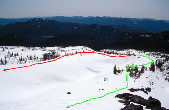
Swift Creek divides the banks….east bank and west bank. Climbers are to take the west bank (green line) along the creek to the lava flows and to the summit, not on the east bank (red line) for safety.


4,800’ marker says “Beyond this point visitors must display a climbing permit.” Without climber registration, hikers are not allowed to climb beyond this point. Above 5,000’ the snow was wet and slushy. I took off my snowshoes and put on crampons. View west of Worm Flows Route around 5,000'.


A small weather station serves as a route marker at 5,600', which marks about a half way distance from the trailhead. 2,800’ to climb to reach the summit from this point. View east is Mt. Adams (12,281').
 Panoramic view at 5,600' - Mt. Adams and Mt. Hood are seen in skyline.
Deceiving summit rim? Looking up toward the summit as you climb, you notice this ridge line which looks like the summit rim. But it is NOT the summit. You still have another 3,000' to climb from here.

View southwest from 6,500’, right above the deceiving ridge. The valley down below is Cougar and Yale Lake. I-5 and Columbia River are vaguely visible in horizon.

 |
| Climbers glissade down near the summit rim. |

View of Mount St. Helens summit rim - breathtaking! Witness the history of the 1980 eruption which took a huge chunk of the mountain top and left this gigantic crater and you realize the magnitude of the living force of mother nature. Steams come out of the active lave dome. Spirit Lake is at the foot of Mt. Margaret and Mt. Rainier (14,411') stands majestic in the north.


At the crater rim. Be careful not to stand too close to the edge of the rim. The true summit of Mount St. Helens – 8,365’. STAY OFF the
cornice!
 |
| Steaming lava dome. |

View of the crater of Mount St. Helens - steaming lava dome as foreground, and Spirit Lake and Mt. Margaret as background.
The last major volcanic activity on May 18, 1980 caused a catastrophic eruption which 57 people; 250 homes, 47 bridges, 15 miles of railways, and 185 miles of highway were destroyed. The eruption triggered a massive debris avalanche reducing the elevation of the mountain's summit from 9,677’ to 8,365’ and created a 1 mile wide horseshoe-shaped crater. The Johnston Ridge Observatory (JRO) is located at the end of the Spirit Lake Memorial Highway (HWY 504). The observatory brings visitors within five miles of the north side of the volcano and offers spectacular views of the still-steaming lava dome, crater, pumice plain and landslide deposit. JRO is located on Johnston Ridge which was named in honor of U.S. Geological Survey (USGS) volcanologist David A. Johnston who was on duty at the USGS, Coldwater II observation post during the May 18, 1980 eruption. David Johnston was one of 57 people who lost their lives in the eruption. He was the first to report the eruption, transmitting the famous message "Vancouver! Vancouver! This is it!" before being swept away by the lateral blast created by the collapse of the mountain's north flank. Ham radio operator Jerry Martin observed the lateral blast overtaking Johnston's camp. Though Johnston's remains have never been found, remnants of his USGS trailer were found by state highway workers in 1993.

Pay attention to follow the route you came from as you descend - Worm Flows Route, or end up going to a wrong direction!
 |
| Trail markers to guide you. |

Remember all climbers must sign-in and sign-out at the Climber's Register (Lone Fir Resort) before and after their climb. I signed out after 9pm.....good reason to start climbing early!

View north of the crater rim. Snow covered lava dome down below.

View of Worm Flows Trail above timberline. Chocolate Falls on the left and Mount St. Helens rises ahead.

View of 1 mile long crater rim at the summit.
Subscribe to:
Posts (Atom)